A) likely
B) unlikely
D) undefined
Correct Answer

verified
Correct Answer
verified
Multiple Choice
Use your knowledge of plate boundaries to answer whether a volcano is likely or unlikely to form at the location of the red triangle. 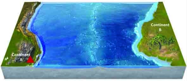
A) likely
B) unlikely
D) undefined
Correct Answer

verified
Correct Answer
verified
Multiple Choice
Use your knowledge of plate boundaries to answer whether a volcano is likely or unlikely to form at the location of the red triangle. 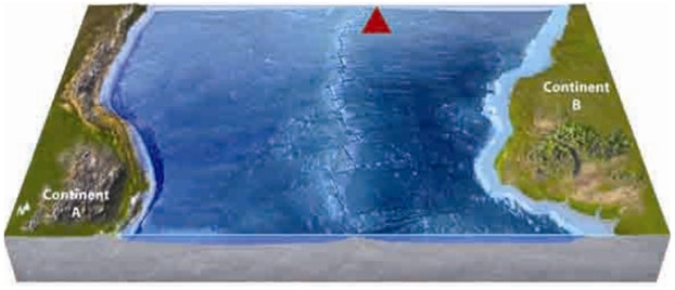
A) likely
B) unlikely
D) undefined
Correct Answer

verified
Correct Answer
verified
Multiple Choice
On the accompanying map, volcanic eruptions are most likely at locations 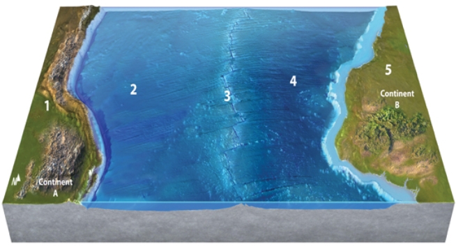
A) 1 and 2.
B) 2 and 3.
C) 3 and 4.
D) 1 and 3.
E) 2 and 5.
G) A) and C)
Correct Answer

verified
Correct Answer
verified
Multiple Choice
Which of the layers in the diagram below are solid or mostly solid? 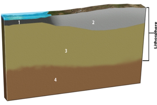
A) 1 and 2
B) 2 and 3
C) 1, 2, and 3
D) All of them.
F) None of the above
Correct Answer

verified
Correct Answer
verified
Multiple Choice
How did the Red Sea, shown between Arabia and Africa in this figure, form? 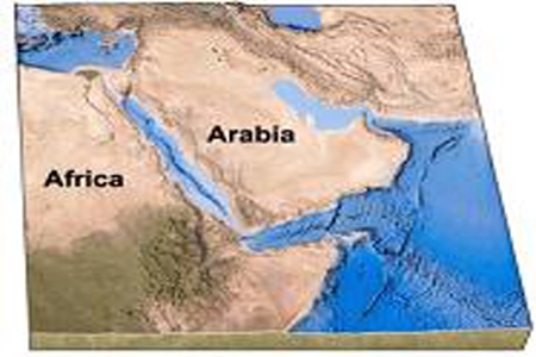
A) subduction of Arabia beneath Africa
B) subduction of Africa beneath Arabia
C) a continental collision
D) continental rifting followed by seafloor spreading
E) transform faulting followed by a continental collision
G) B) and E)
Correct Answer

verified
Correct Answer
verified
Multiple Choice
Most oceanic plateaus are
A) small pieces rifted apart from continents.
B) places where the seafloor has been buckled upward by convergence.
C) constructed by volcanic eruptions probably over mantle plumes.
D) large fan-shaped mounds deposited by turbidity currents.
F) A) and D)
Correct Answer

verified
Correct Answer
verified
Multiple Choice
What is associated with reversed magnetic polarity?
A) A compass needle would point south.
B) The magnetic signal of seafloor formed with this polarity would be stronger compared to adjacent areas of the seafloor.
C) There are much fewer intervals of reversed polarity than normal polarity.
D) All of these.
F) A) and C)
Correct Answer

verified
Correct Answer
verified
Multiple Choice
Which of the following is NOT the name of a supercontinent?
A) Gondwana
B) Laurasia
C) Pangaea
D) Rodinia
E) Tethys
G) B) and E)
Correct Answer

verified
Correct Answer
verified
Multiple Choice
Which of the following is NOT a type of terrane in California?
A) oceanic crust
B) island arcs
C) accretionary prism
D) displaced granitic rocks
E) All of these are present in California.
G) B) and D)
Correct Answer

verified
Correct Answer
verified
Multiple Choice
In order for a terrane to become attached to a continent, it typically
A) is shifted there suddenly by an earthquake.
B) originated as a meteor that fell over a continent.
C) becomes scraped of a subducting plate.
D) is transported by a glacier.
E) results from the collision of two continental plates.
G) B) and D)
Correct Answer

verified
Correct Answer
verified
Multiple Choice
What type of plate boundary is depicted in this figure? 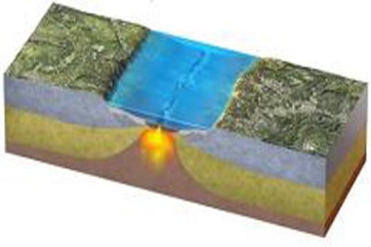
A) oceanic divergent boundary
B) ocean-ocean convergent boundary
C) ocean-continent convergent boundary
D) continental collision boundary
E) transform boundary
G) B) and C)
Correct Answer

verified
Correct Answer
verified
Multiple Choice
The light blue area just off the Australian coast, as shown here, is called the 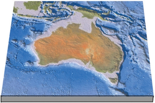
A) continental platform.
B) seashore.
C) continental shelf.
D) abyssal plain.
F) B) and C)
Correct Answer

verified
Correct Answer
verified
Multiple Choice
What causes magnetic stripes on the seafloor, such as those shown here? 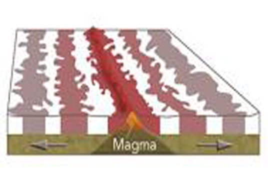
A) Volcanic rocks in oceanic crust are covered by a variable thickness of sediment.
B) Some oceanic crust consists of volcanic rocks and some is composed of sediment.
C) Sometimes Earth's magnetic field points north and sometimes it points south.
D) Some volcanic rocks are formed in normal ways and others have pillows.
F) All of the above
Correct Answer

verified
Correct Answer
verified
Multiple Choice
On this map of the South Atlantic, which letter is on a transform fault? 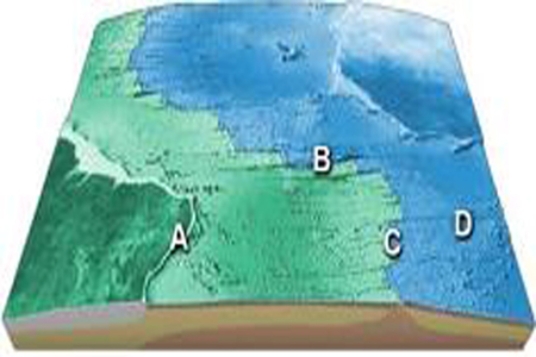
A) A
B) B
C) C
D) D
F) None of the above
Correct Answer

verified
Correct Answer
verified
Multiple Choice
What is being depicted by this figure? 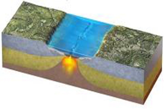
A) continental collision
B) continent-continent convergence
C) early stages of seafloor spreading
D) early stages of subduction
E) a boundary that is mostly a transform fault
G) A) and E)
Correct Answer

verified
Correct Answer
verified
Multiple Choice
Where was North America 150 million years ago?
A) next to Antarctica
B) next to Australia
C) over the south pole
D) closer to Africa and South America
E) None of these.
G) A) and C)
Correct Answer

verified
Correct Answer
verified
Multiple Choice
Which location on this figure from the Investigation is located on a passive continental margin? 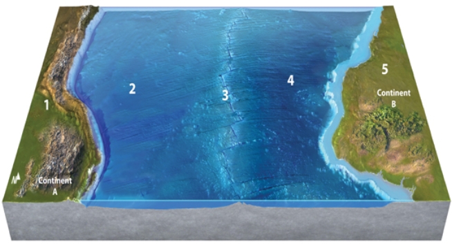
A) 1
B) 2
C) 3
D) 4
E) 5
G) A) and B)
Correct Answer

verified
Correct Answer
verified
Multiple Choice
The red dots that coincide with volcanically active island chains shown on the map are called 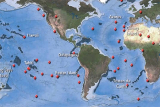
A) hot spots.
B) mid-ocean ridges.
C) abyssal plains.
D) island arcs.
F) C) and D)
Correct Answer

verified
Correct Answer
verified
Multiple Choice
How fast do plates move relative to one another?
A) centimeters per year
B) meters per year
C) kilometers per year
D) one hundred kilometers per year
F) A) and B)
Correct Answer

verified
Correct Answer
verified
Showing 41 - 60 of 139
Related Exams